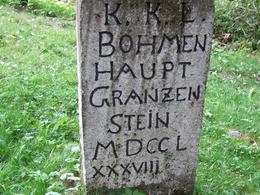
Hauptgrenzstein
Ve starověku byl Mühlviertel hraničním územím (Vltava - Dunaj) mezi mocenskými sférami Římanů a germánských kmenů (Markomanů).
During the main settlement period after 600, the watershed of the Bohemian Forest was an approximate border between Bohemia and Bavaria or Austria.
Under Empress Maria Theresa and especially Emperor Joseph II, the borders were precisely fixed (1764 - 1788). The mapping carried out at that time is known as the "Josephinische Militäraufnahme".
Inscription: "KKL-Operösterreich-Haupt.Granzen-Stein-MDCCL-XXXVII" = Kaiserlich-König-Licher (Kingdom of Bohemia) / Oberösterreich / Hauptgrenzstein / 1788.
4170 St. Oswald bei Haslach
Phone +43 5 07263 - 200
E-Mail boehmerwald@muehlviertel.at
Web www.muehlviertel.at/
Contact person
Tourismusverband Mühlviertel – Informationsbüro Böhmerwald
Dreisesselbergstraße 18/1
4160 Aigen-Schlägl
Phone +43 5 07263 - 200
Fax machine +43 5 7890 - 115
E-Mail boehmerwald@muehlviertel.at
Web www.muehlviertel.at
Depending on snow conditions!
- open to the public
- Suitable for groups
- Suitable for schools
- Suitable for kids (all ages)
- Pets allowed
- Suitable for seniors
- Suitable for single travelers
- Suitable for friends
- Suitable for couples
- Suitable for children
Please get in touch for more information.
Your enquiry
Do you have any questions? Do not hesitate to contact us!
Fields marked with an asterisk (*) are obligatory
Propose changes
Please let us know how we can improve the quality of this property, or if there is any incorrect information on this page (e.g. opening hours, contact, etc.).
Fields marked with an asterisk (*) are obligatory


