Danube Cycle Path Stage 1 North Bank: Passau - Schlögen


4040 Linz

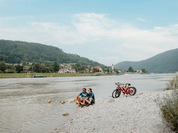
From Bavarian Venice to the Giant of the Danube
Recommended season:
- March
- April
- May
- June
- July
- August
- September
- October
- November
- Multi-stage route
- Scenic
- Refreshment stops available
- Family friendly
- Cultural/historical value
- Geological highlights
- Botanical highlights
From Bavarian Venice to the Giant of the Danube
North or South route – this is the question at the start of your first stage, as you can reach the day's destination on both Danube banks. Regardless of your choice: Before you set off, you have ample opportunity to visit Passau’s sights such as the old town, residence, and St. Stephen's Cathedral (see also E1-S). As soon as you cross the Danube on the Luitpold Bridge, the fortresses Ober- and Niederhaus greet you in farewell from the city of three rivers. Oberhaus, long the seat of the Passau bishops, houses among other things a city and medieval museum.
Tip for culture lovers: Start your cycling route in the baroque town of Schärding with its beautiful Silver Row. From there, you can comfortably reach Passau and the Danube Cycle Path via the Inn Cycle Path.
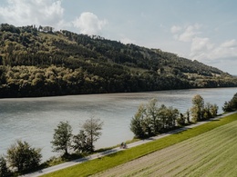
Very impressive are soon the sunny southern slopes of the Donauleiten nature reserve, home to the delicate alpine violet, the magnificent Turk's cap lily, and the shimmering emerald lizard. Through the village of Erlau you head to Obernzell, where a ceramics museum is housed in the massive castle directly on the river. Your onward journey is accompanied by a view of the mighty keep of Vichtenstein Castle (12th century) on the opposite bank, where the Haugstein (895 m), the highest elevation of the Upper Austrian Sauwald, also towers.
The Nature Experience Center Haus am Strom, shaped by architects like "wave and pebble," welcomes you among other things with a special water elevator. A series of interesting and engaging nature tours introduce you to the fauna and flora of the region. If the view of Engelszell Abbey tempts you for a short visit on the opposite bank (see also E1-S), you can cross the Danube via the Jochenstein power plant.
On the north bank, you soon reach Niederranna (Danube bridge), where a long-established boat builder invites you for a Zille boat trip on the water. Now it is not far until you can either cross by ferry to Schlögen or continue the stage on the north bank with a refreshing ride through the Schlögener Schlinge by Donaubus, the Au-Grafenau cross-river ferry.
Directions:Passau - Ilzstadt - Erlau - Obernzell - Niederranna - Schlögen
Route description
You begin the stage directly at Passau station. To reach the Danube as quickly as possible, follow the signs "to the Danube Cycle Path" and shortly afterwards you will catch your first glimpse of your future companion. Follow the river downstream and cross the Danube over the Luitpold Bridge. Here you can already see the Ober- and Niederhaus fortress, which combines the administrative center, residence, government buildings, and fortress in one.
After crossing the Ilz Bridge, keep right and from now on always follow the marked path along the Danube. You will soon enter the Donauleiten nature reserve, whose steep slopes mark the southern edge of the Bavarian Forest. The slopes are mostly densely forested, with bizarre rock formations visible in only a few spots. Due to the steep terrain and southern exposure, the nature in this area is largely untouched and impresses with a diverse flora and fauna.
In Erlau, you cross the eponymous stream and follow the cycle path to Obernzell. Soon, on the other side of the river, the mighty Vichtenstein Castle from the 12th century comes into view, and slightly offset is the 895 m high Haugstein, considered the highest elevation in the Alpine foreland. A few kilometers downstream you pass the "Haus am Strom," whose architecture resembles the shape of a wave. With numerous water features, an exhibition, and a beer garden with regional cuisine, the house offers a welcome destination for a break. As an alternative to continuing with a view of Engelszell Abbey, there is the option to cross the Danube over the Jochenstein power plant and return to the north bank with the Engelhartszell bike ferry.
In Niederranna, with the Witti Zille rental, one of the last Zille builders can be found. Shortly after the Haichenbach ruin, the famous Schlögener Schlinge begins on the ridge, where the Danube describes a picturesque 180° curve. The stage ends with a short ferry crossing over the Danube to Schlögen or with a Donaubus ride (Au-Grafenau cross-river ferry) through the Schlögener Schlinge to Grafenau.
Tip:Discovery journeys with pleasurable stops! This route passes directly by the following culinary partners:
- Thalhammers in Feldkirchen
- Wögerer in Feldkirchen
- Hotel Fautschlöss'l in Feldkirchen
- Donautaler Mostkellerei in Obermühl
- Hotel Wesenufer in Waldkirchen am Wesen
- Gasthof Luger in Neustift
- Hotel Donauschlinge in Haibach
- DonAu-Standl in Au an der Donau
- Radlerbauernhof Moser in Mitterkirchen
Paths covering:
further information:
- Multi-day tour
- Board possible
")
")
")

")
")
")
")

Direction information: Departure
Direction information: Destination
Getting there
Take the E56 to the Passau-Mitte (116) exit and then follow the B12 towards Fürstenzell/Danube. Turn right directly at the Danube onto the B8/Regensburger Straße and follow the signs to "station".
Public Transit
By train to Passau main station.
Parking
Parking in Passau.
- Suitable for families
- Suitable for children
- Spring
- Summer
- Autumn
- Early winter
Please get in touch for more information.
Lindengasse 9
4040 Linz
Phone +43 732 7277 - 800
Fax machine +43 732 7277 - 804
E-Mail info@donauregion.at
Web www.donauregion.at
Web www.donauregion.at/
https://www.donauregion.at/
Vis-à-vis users
1. The tours presented for hiking, walking, biking and road biking, mountain biking, motorbiking, horseback riding, climbing, cross-country skiing, and going on skiing and snowshoe tours etc. are to be considered non-paid tour recommendations and only serve as non-binding information. We have no intention of concluding a contract with the users of this website. The utilisation of the data does not lead to the establishment of a contract with us.
The data may only be used for private use; any commercial use is prohibited. In particular, it is not permissible to offer the data on commercially run websites, file-sharing platforms etc. or to use it to develop commercial products. Downloading data does not imply that users are granted rights to the data concerned.
The tour recommendations posted were created with utmost care; nevertheless, we assume no liability for the correctness and completeness of the information.
We point out that neither the tour recommendations included on this website nor the associated data and information were posted by us, but rather by third parties (Art. 16 Austrian E-Commerce Act). We have no influence on whether the details provided (e.g. distance, level of difficulty, change in altitude, description etc.) are authentic, correct and complete. We do not review these third-party contents. For this reason, we assume no liability for the authenticity, correctness and completeness of the information.
Construction-related measures or other influences (e.g. landslides and similar occurrences) can lead to temporary or permanent changes in a route (e.g. loss of a bridge and similar occurrences). Such occurrences can lead to part of the route or the entire route becoming impassable.
The use of the data as well as undertaking (riding, walking, taking etc.) the recommended tours or using the network of paths occurs at users’ own risk and on their authority. In particular, users themselves are responsible for the choice of route, outdoor orientation, adherence to traffic rules, supplies and equipment for tours listed in Point 1 (e.g. bicycle etc.), wearing a helmet, estimating their own fitness, recognising dangers and maintaining an appropriate velocity. We exclude ourselves from any liability whatsoever for damages, in particular accidents, that occur whilst taking part in the recommended tours.
2.Some of the tours lead over roads with normal traffic conditions. Please observe that there is an increased risk which can be avoided by means of appropriate attention and proper estimation and implementation of one’s own abilities. For this reason, please travel a route that is unfamiliar to you slowly and with special care. Pay constant attention to potential dangers and always observe traffic. Do not leave the routes featured in descriptions.
The potential use of private roads, in particular forestry roads and agricultural transport roads, can be subject to legal restrictions, which must be observed and adhered to.
The normal traffic rules apply. Each user (e.g. biker, motorbiker) is responsible for adhering to these rules and maintaining his/her bike/vehicle and its equipment (lights, brakes etc.) in good working order. Each user is also responsible for ensuring that he/she rides at a velocity that is appropriate for the conditions and his/her skill level and for maintaining sufficient distance to the rider in front. We explicitly recommend adjusting velocity to correspond to the respective field of vision, wearing a helmet, using reflective clothing (or similar) and employing bicycle lights in line with regulations.
3.Each tour requires good physical fitness as well as detailed planning. We explicitly recommend only taking the tours in the case of optimal healthiness.
We recommend that you conclude an accident and liability insurance policy. Use an onboard computer that displays the respective kilometres travelled per day and is calibrated for the front wheel.
4.Special for mountain bikers – Fair-play rules:
Mountain biking is one of the most wonderful outdoor leisure-time activities. Whilst biking or on a mountain biking tour, mountains and lakes, meadows and cabins are re-discovered in new ways. A couple of rules for fair play in the forest help to avoid conflicts whilst mountain biking.
a.Pedestrians have the right of way: We are accommodating and friendly to pedestrians and hikers. Upon encountering these fellow travellers, we alert them by using the bicycle bell and slowly overtake them. We avoid paths with heavy pedestrian traffic altogether. Take nature into account: We do not leave refuse behind.
b.The braking distance should be half of the total distance visible: We ride at a controlled pace, are ready to brake and maintain a braking distance half as long as the total distance visible, especially in curves, because we always have to count on obstacles on the path. Damage to the path, stones, branches, wood piles, grazing livestock, cattle grids, barriers, tractor-type forestry machines and authorised vehicles pose dangers that we need to be ready for.
c.Don’t drink and drive!: Do not drink alcohol when mountain biking. Take care at stop-off points (dealing with bike racks, dirty shoes or clothing).
It is obligatory to provide first aid!
d.Marked routes, closed paths and blockades: Keep to the marked routes, observe the blockades and accept that these roads are primarily for agricultural and forestry use!
Blockades can often not be avoided and are in your own interest. Biking beyond the intended path and outside of opening times is punishable and turns us into illegal bikers.
e.We are guests in the forest and behave accordingly, including vis-à-vis forestry and hunting staff. Whilst mountain biking, mobile telephones and music players are forbidden! Biking requires your full attention.
f.Avoid unnecessary noise. Out of consideration to the animals living in the wild, we only bike during full daylight. As a principle, we always wear our helmet (even when riding uphill)! Don’t forget emergency supplies: We always have a repair set and bandages along.
g.Don’t overestimate your skills: We should not overdo it when it comes to biking technique and physical fitness. Take the level of difficulty posed by the route into consideration and make a precise estimate of your experience and skills as a biker (braking, bell, lights)!
h.Close gates: We approach grazing livestock at a walking pace and close every gate behind us. We should avoid causing escape and panic reactions in the animals. Nothing stands in the way of the fun and athletic challenge in the mountains and forests!
i.Traffic rules: The general traffic rules (StVO) apply for all the mountain biking routes and we adhere to them. Our bike therefore needs to be in perfect technical condition and equipped in line with the traffic rules, including brakes, a bell and lights. We inspect and service our mountain bikes regularly anyway.
5.We assume no liability for the contents of external websites; in particular, we assume no liability for their statements and contents. Moreover, we have no influence on the design or contents of the websites to which hyperlinks on www.muehlviertel.at lead or from which hyperlinks lead to www.muehlviertel.at. There is no on-going review of websites to which hyperlinks on www.muehlviertel.at lead or from which hyperlinks lead to www.muehlviertel.at. We do not appropriate the contents of websites to which hyperlinks on www.muehlviertel.at lead or from which hyperlinks lead to www.muehlviertel.at.
Vis-à-vis bloggers
PLEASE OBSERVE:
1. Each of your tour recommendations for hiking, walking, biking and road biking, mountain biking, motorbiking, horseback riding, climbing, cross-country skiing, and going on skiing and snowshoe tours etc., along with other details and information, is free of charge. In particular regarding the correctness of the information, we assume no liability, nor do we assume any liability whatsoever for the consequences of the use of your tour recommendation by a third party (in particular by a user of this website). We do not review the tour recommendations you post, including other details and information, at any time.
We have no intention of concluding a contract with persons who post tour recommendations and/or other details and information on this website. Posting data (information) does not imply that a contract has been concluded.
By recommending a tour, we assume special responsibility vis-à-vis other athletes. Please take this responsibility seriously and describe your tour recommendation with utmost care and to the best of your knowledge and belief.
2.Your tour recommendations must therefore clearly and unambiguously include at least the following criteria and provide a sufficiently detailed description:
• Starting point
• Detailed route description
• Distance/Overall distance
• Level of difficulty
• Dangerous spots
• Average duration of trip
• Change in altitude
• Finishing point.
If possible, please provide the change in altitude.
3.When you post a tour recommendation, you give us the order to save your tour recommendation and/or the details you provide on our website and to make it/them accessible to third parties, in particular to users of this website, in the long term. We reserve the right to block or delete tour recommendations and/or other details and/or information that you post, either partially or entirely, at any time without providing a justification. Should this occur, it grants you no rights whatsoever.
Thank you for your efforts!
4. We are not responsible for the contents of external websites; in particular, we do not assume any liability for their statements or contents. Furthermore, we do not influence the design or contents of websites that can be accessed from www.muehlviertel.at via hyperlinks or that use hyperlinks to refer to www.muehlviertel.at. The websites that can be accessed from www.muehlviertel.at via hyperlinks or that use hyperlinks to refer to www.muehlviertel.at are not regularly monitored. Furthermore, we do not assume any claims to the websites that can be accessed from www.muehlviertel.at via hyperlinks or that use hyperlinks to refer to www.muehlviertel.at.
Altitude profile - Danube Cycle Path Stage 1 North Bank: Passau - Schlögen
Ihre Anfrage
Do you have any questions? Do not hesitate to contact us!
Please fill in all fields marked *.
Propose changes
Please let us know how we can improve the quality of this property, or if there is any incorrect information on this page (e.g. opening hours, contact, etc.).
Please fill in all fields marked *.